


A significant winter weather system continues to sweep through Southeast Michigan this week, bringing a mix of heavy snow, freezing rain, and plummeting temperatures that have paralyzed parts of the region’s transportation network. As accumulation totals rise, residents are facing substantial Detroit winter storm impacts, ranging from hundreds of grounded flights at Detroit Metropolitan Wayne County Airport (DTW) to treacherous driving conditions on major interstate arteries.
The National Weather Service (NWS) office in White Lake issued a winter weather advisory early this morning, warning of slippery road conditions and reduced visibility. With the storm expected to linger through the evening commute, city officials and transportation agencies are urging Detroiters to exercise extreme caution and avoid unnecessary travel.
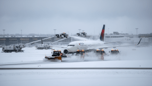
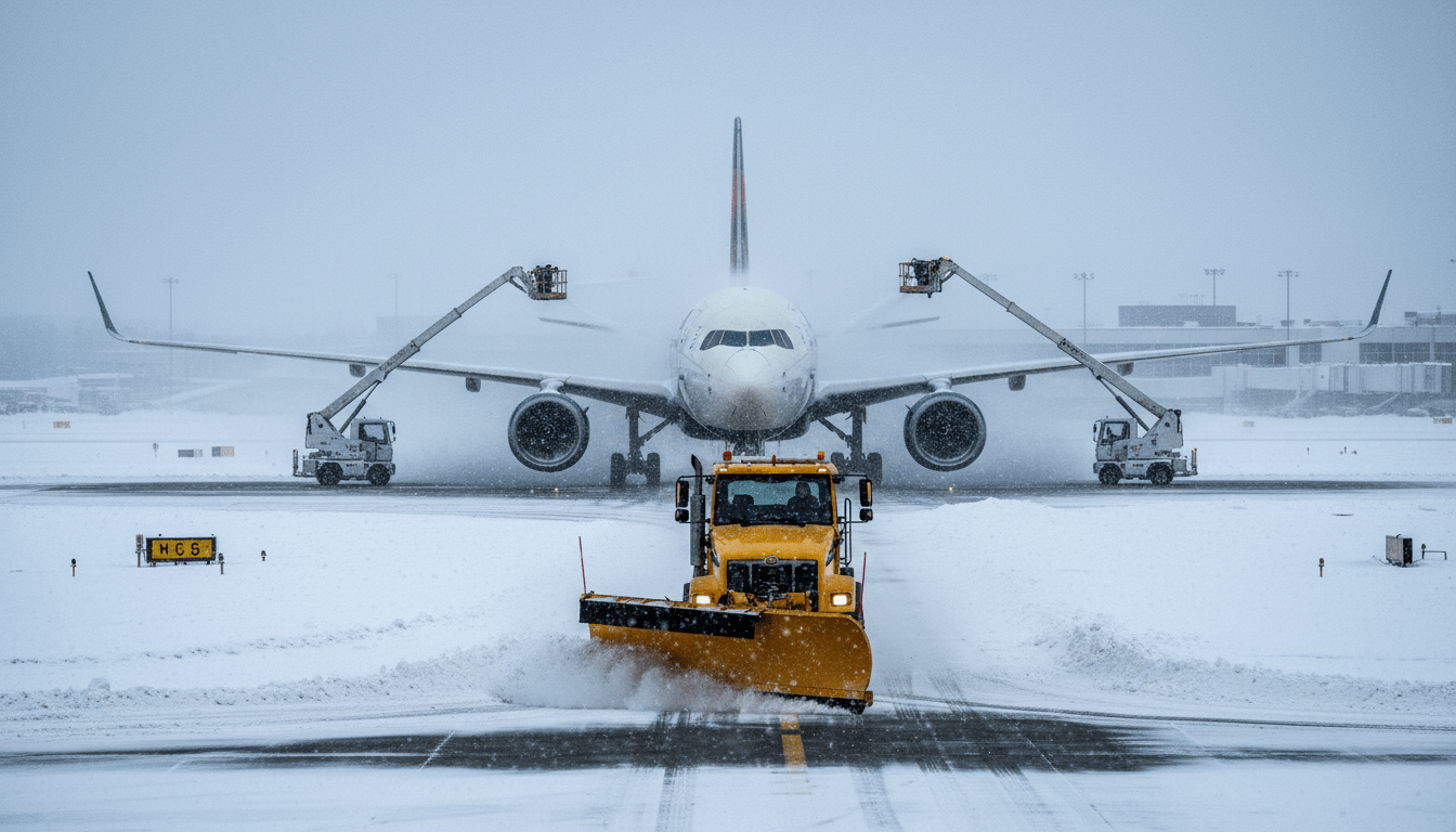
Aviation Standstill: DTW Struggle with Ice and Snow
Travelers attempting to fly in or out of the region are facing significant hurdles today. Detroit Metropolitan Airport, a major hub for Delta Air Lines, has reported extensive disruptions due to the need for rigorous de-icing procedures and runway clearing operations.
According to data from flight tracking service FlightAware, more than 350 flights originating from or destined for DTW have been canceled as of mid-day, with an additional 400 flights experiencing significant delays. The cascading effect of these cancellations is being felt across the national airspace system, but the brunt of the frustration is concentrated here in Romulus.
Airport officials released a statement urging passengers to check their flight status before heading to the terminal. “Our crews are working around the clock to keep runways and taxiways clear,” a DTW spokesperson said in a press briefing. “However, safety is our priority. Aircraft de-icing during active precipitation takes time, and visibility requires increased spacing between arriving aircraft.”
For those stranded at the airport, the situation is a test of patience. The slowdowns are not merely a result of local snow accumulation but also involve managing the complex logistics of ground crews working in sub-freezing temperatures. Travelers are encouraged to utilize airline apps for the most up-to-date rebooking options rather than waiting in long lines at ticket counters.
Highways and Surface Streets: A Commuter’s Nightmare
While the skies remain clogged, the situation on the ground is equally precarious. The Michigan Department of Transportation (MDOT) has deployed its full fleet of salt trucks and plows across Metro Detroit, yet the rapid rate of precipitation has made it difficult to keep pavement bare.
Reports from the Michigan State Police indicate a sharp increase in spin-outs and fender-benders along I-75, I-94, and the Lodge Freeway. specifically, the interchange near I-696 saw significant slowing earlier today due to black ice formation on ramps and bridges. MDOT reminds drivers that “Ice and Snow, Take It Slow,” advising motorists to leave at least six car lengths between vehicles.
“The roads are deceptively slick,” said a representative from the Detroit Police Department’s traffic division. “Even if the snow looks cleared, patches of ice are hiding underneath, particularly on overpasses which freeze faster than surface roads.”
For more information on current road closures and construction zones that may complicate snow removal, residents can review our recent coverage on Detroit infrastructure updates.
Impact on Detroit Residents and Neighborhoods
Beyond the highways and runways, the storm is affecting the daily lives of Detroiters in neighborhoods from Corktown to the far East Side. The City of Detroit’s Department of Public Works has activated its snow emergency routes, meaning street parking restrictions are in effect to allow plows to pass. Residents parked on marked snow emergency routes must move their vehicles to avoid ticketing and towing.
School closures were widespread across Wayne, Oakland, and Macomb counties today. The Detroit Public Schools Community District (DPSCD) announced the suspension of classes early this morning to ensure the safety of students and staff. Parents are advised to monitor local news outlets for updates regarding tomorrow’s schedule, as temperatures are expected to drop further overnight, potentially freezing the slush currently on the ground.
Local businesses are also feeling the pinch. Restaurant owners in Midtown have reported a sharp decline in lunch traffic. “It’s a ghost town out there right now,” said the manager of a popular diner on Cass Avenue. “When the weather turns like this, people just hunker down. We are keeping the coffee hot for the plow drivers, though.”
Furthermore, there is a looming concern regarding power stability. Heavy, wet snow and ice accumulation on tree branches pose a risk to power lines. DTE Energy has mobilized field crews to respond to potential outages. Residents are reminded to stay at least 20 feet away from any downed power lines and report them immediately to the utility provider.
Background & Climatological Context
While Detroit is no stranger to winter fury, the timing and composition of this system are notable. Data from the National Weather Service indicates that this storm system is drawing moisture from the Gulf of Mexico and colliding with an arctic air mass descending from Canada. This specific setup is known for producing “heavy wet” snow, which is significantly harder to clear than dry, powdery snow.
Historically, February is a volatile month for Detroit weather. This current system mirrors the atmospheric patterns seen during the heavy snowfall events of early 2014, though accumulation totals this time are predicted to be slightly lower. However, the mix of ice and sleet makes the driving conditions arguably more dangerous than a pure snow event.
According to National Weather Service Detroit/Pontiac data, the region has seen fluctuating winter severity over the last decade, with a trend toward more frequent freeze-thaw cycles that wreak havoc on road infrastructure, contributing to the notorious pothole season that follows.
What Happens Next: The Outlook
Looking ahead to the next 24 hours, the precipitation is expected to taper off, but the cold air will remain. The primary concern for the overnight hours is the “flash freeze” of wet surfaces as temperatures dip into the teens. Salt becomes less effective at very low temperatures, meaning morning commuters should expect continued slick spots.
Travelers with flight plans for tomorrow should continue to monitor their airline status, as crews at DTW work through the backlog of grounded aircraft. It often takes airlines 24 to 48 hours to fully normalize operations following a disruption of this magnitude.
Residents are encouraged to check on elderly neighbors who may struggle with snow removal or need assistance obtaining groceries during the cold snap. For ongoing coverage on how the city is managing these conditions, stay tuned to Detroit City News community alerts.