



Detroit, a city synonymous with the automobile, is currently undergoing a significant transformation in how its residents navigate the urban landscape. Over the last five years, the city has aggressively pursued a strategy to diversify its mobility options, moving away from a strictly car-centric model toward a more multimodal approach. Recent initiatives to expand protected bike lanes, complete the Joe Louis Greenway, and bolster car-sharing and bike-sharing programs are reshaping the daily commute for thousands of Detroiters.
The push for these local transportation alternatives comes as city planners and community leaders seek to address long-standing issues regarding transit equity, last-mile connectivity, and environmental sustainability. While the personal vehicle remains the primary mode of transport for the majority of the region, the infrastructure supporting non-motorized and shared transport is growing at a pace unseen in the city’s history.
Expanding the Network: The Rise of Protected Bike Lanes
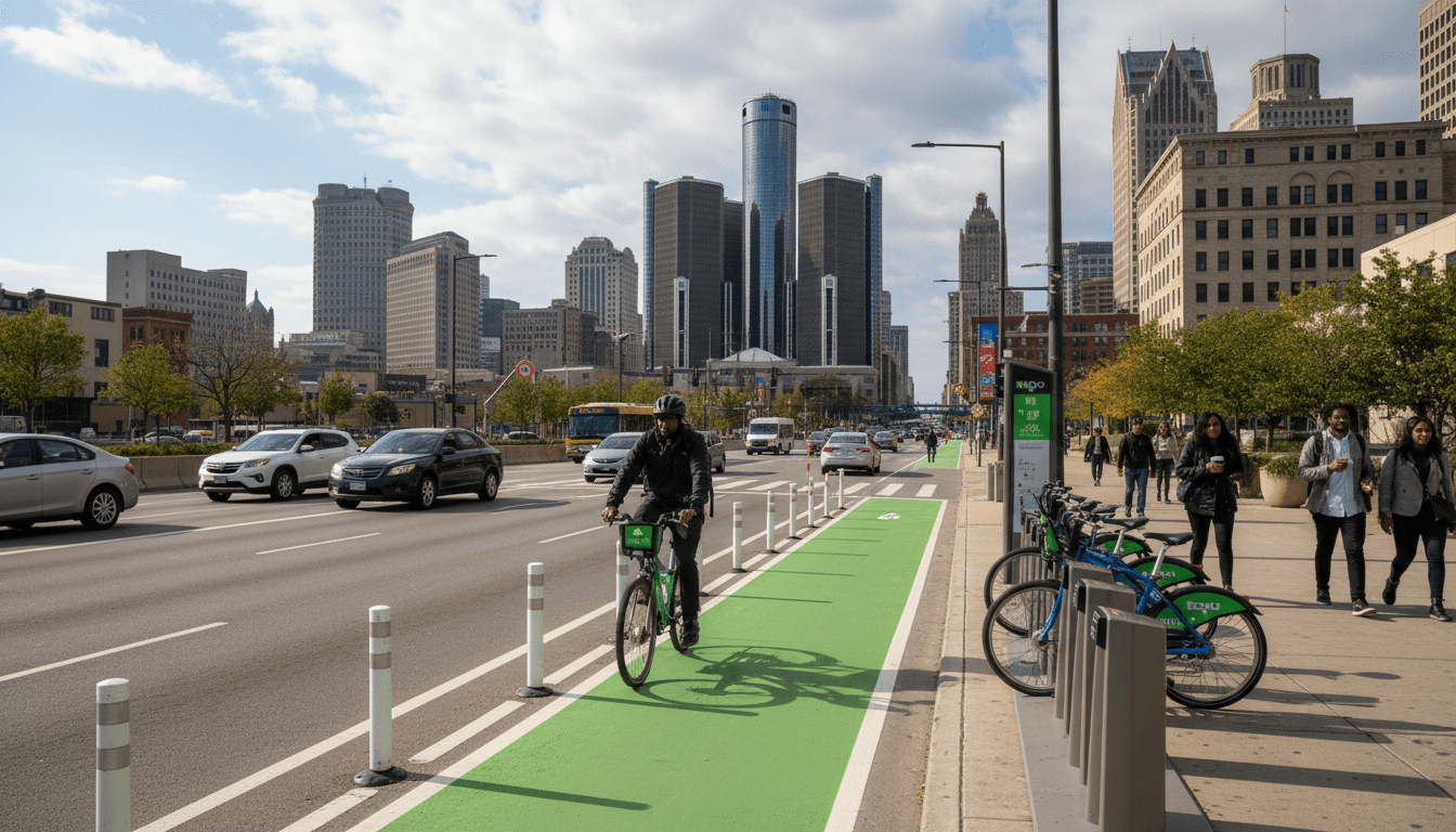
At the heart of this shift is the physical restructuring of Detroit’s streets. The Department of Public Works (DPW) has been implementing “streetscape” overhauls across key corridors such as Livernois Avenue, Grand River Avenue, and East Jefferson. These projects often involve road diets—reducing the number of lanes for cars—to accommodate wider sidewalks and protected bike lanes.
According to the City of Detroit’s Complete Streets program, the goal is to design roadways that are safe for all users, regardless of age or ability. The most ambitious of these projects is the Joe Louis Greenway, a 27.5-mile loop that will eventually connect 23 different neighborhoods to the Detroit riverfront. Once completed, it will provide a continuous off-road path for cyclists and pedestrians, linking Detroit to the neighboring cities of Hamtramck, Highland Park, and Dearborn.
“The expansion of bike lanes is not just about recreation; it is about providing a viable transportation alternative for residents who do not own a car or choose not to drive for short trips,” said a spokesperson for the Detroit Greenways Coalition in a recent press briefing. “Connecting neighborhoods to job centers like Downtown and Midtown is critical for economic mobility.”
This infrastructure build-out is supported by significant federal and local funding, including allocations from the American Rescue Plan Act (ARPA), which have allowed the city to accelerate construction timelines on several key segments of the network.
Shared Mobility: MoGo and Car-Sharing Services
Complementing the physical infrastructure is the growth of shared mobility services. MoGo, Detroit’s non-profit bike-share system, has become a staple in the city’s transportation ecosystem since its launch. With stations located throughout the greater downtown area and expanding into neighborhoods, MoGo provides a critical “last-mile” solution for residents using the QLine or DDOT buses.
Data from local transit studies suggests that integrating bike-share systems with public transit increases overall ridership. By placing stations near bus stops and mobility hubs, the city is making it easier for residents to travel without relying on a private vehicle. MoGo offers various pass options, including affordable annual passes for residents receiving state benefits, ensuring that Detroit transportation alternatives remain accessible to low-income households.
On the car-sharing front, options like Zipcar and peer-to-peer platforms have seen fluctuating presence in the city, but demand remains steady in dense areas like Midtown and Corktown. These services allow residents to forgo the high costs of car ownership—insurance, maintenance, and parking—while still having access to a vehicle for occasional heavy-duty errands or trips outside the city limits. This model is particularly attractive to the student populations at Wayne State University and young professionals moving into the city’s core.
Impact on Detroit Residents
For longtime residents, these changes bring both opportunities and adjustments. The primary benefit cited by advocates is the reduction in household transportation costs. In a city where car insurance rates are among the highest in the nation, the ability to rely on cycling, walking, or shared transit can result in savings of thousands of dollars annually per household.
Furthermore, these improvements are often tied to broader neighborhood revitalization projects. Improved streetscapes tend to attract small businesses and increase foot traffic, boosting the local economy. On avenues like Livernois, known as the “Avenue of Fashion,” the introduction of wider sidewalks and bike lanes has coincided with a resurgence of retail and dining establishments.
However, the transition is not without friction. Some residents have expressed concerns about the reduction of vehicle lanes increasing traffic congestion during peak hours. Additionally, community engagement remains vital to ensure that these developments do not spur displacement or gentrification but rather serve the existing community. City officials have emphasized that community meetings are a prerequisite for major streetscape changes to mitigate these concerns.
Background & Data
The shift toward multimodal transit is backed by shifting demographics and utilization data. According to the Southeast Michigan Council of Governments (SEMCOG), while the region remains heavily car-dependent, non-motorized travel in Detroit proper is higher than in surrounding suburbs. The 2020 Census data and subsequent American Community Survey estimates highlight that a significant portion of Detroit households do not have access to a reliable vehicle, making non-automotive infrastructure a necessity rather than a luxury.
Safety data also drives these decisions. Statistics from the Michigan State Police and local traffic analysis indicate that protected bike lanes and traffic calming measures significantly reduce the rate of pedestrian and cyclist fatalities. By physically separating cars from bikes, the likelihood of severe accidents decreases, encouraging more risk-averse demographics, such as families and the elderly, to utilize these lanes.
Investment figures show a clear priority shift. The city budget allocation for non-motorized infrastructure has seen steady increases over the past three fiscal years, reflecting the administration’s commitment to the “20-minute neighborhood” concept—where residents can access most daily needs within a 20-minute walk or bike ride.
What Happens Next?
Looking ahead, the focus will likely remain on connectivity. The completion of the Joe Louis Greenway is the marquee project on the horizon, but smaller connectors are equally important to knit the network together. Planners are currently evaluating routes to better connect Southwest Detroit and the East Side to the central core.
Innovation in shared mobility is also expected to continue. Discussions regarding electric vehicle (EV) car-sharing programs stationed at public housing developments are in early stages, aiming to bridge the gap between green technology and equitable access. As Detroit continues to evolve, the integration of these Detroit transportation alternatives will play a pivotal role in defining the city’s future livability and economic resilience.